NIGST
site announcements को छोड़ें
पाठ्यक्रम को छोड़ें
पाठ्यक्रम वर्ग को छोड़ें
उपलब्ध पाठ्यक्रम को छोड़ें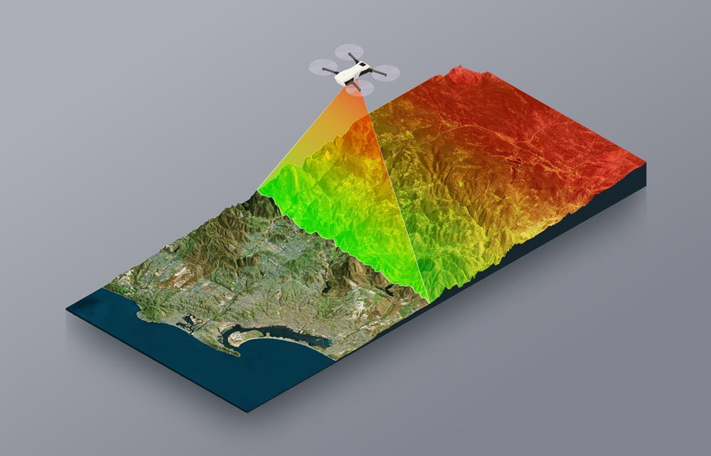
Site announcements
इस मंच में अभी तक कोई विचार-विमर्श का विषय नहीं है।
पाठ्यक्रम को छोड़ें
पाठ्यक्रम
पाठ्यक्रम वर्ग को छोड़ें
पाठ्यक्रम वर्ग
उपलब्ध पाठ्यक्रम को छोड़ें
उपलब्ध पाठ्यक्रम
Surveying Supervisor
- टीचर: ANURAG MISRA
Surveying Engineer
Advanced Course on Geodesy
Advanced Course on LiDAR
Field Astronomy
Course on LiDAR for Practitioner
HP Levelling
ETS Survey for Boundary Work
Open-source tools & solutions for GIS - Advanced
GIS Analysis & Applications
Orientation Programme for Officer Surveyor
Soft Skills Training for SoI
Cyber Awareness (Jagrookta) for SoI
Basic Course on LiDAR
Basic Course on Multispectral Remote Sensing
Basic Course on Tidal Measurement for SoI
Cloud Technology for SoI - Advanced
GIS Analysis & Applications for DST Officials
Street View Survey 360 Camera
Geo-spatial Data Management for SoI GDs
Field Data Updating Using FDCs
Geo-spatial Data Interoperability
Basic Course on Geo-Referencing
Course on AI & ML in Geospatial for SoI
Basic Course on Toponymy for SoI
GDI Workshop for SoI - Advanced
Cloud Technology for SoI - Beginner
Basic Course on Digital Twin
Cyber Security for SoI - Beginners
Basic course on GNSS & CORS
Geoid Modelling for Beginners
Open-source tools & solutions for GIS - Basic
Networking for SoI - Beginners
Basic Course on Reference Frame
Basic Course on Stereo Photogrammetry
Drone Surveying & LiDAR Remote Sensing for DST
GDI Workshop for SoI-Basic
This 5-day course provides a comprehensive introduction to LiDAR technology. Participants will get acquainted with the fundamental physics of laser measurements to the creation of complex 3D geospatial products. The curriculum balances theoretical knowledge with practical workflows, covering hardware components, data acquisition strategies, point cloud processing, and the generation of high-accuracy elevation models. By the end of this course, students will be equipped to manage LiDAR projects, validate data quality, and extract meaningful features for applications in urban planning, forestry, and Digital Twin construction.
- टीचर: ANBUMANI B
Basic Principle of GNSS Operations, Data Processing & CORS
- टीचर: B ANAND
- टीचर: SUNIL DUTT SHARMA
- टीचर: Dr. LAKSHMIKANTHKUMAR NEELAMSETTI
- टीचर: ANURAG MISRA
- टीचर: P MOHAN KRISHNA
- टीचर: YOGACHANDAR P. A.
- टीचर: ANAND SAGAR MEDIKONDU
- टीचर: V. THANG THUAM
- टीचर: Admin User
- टीचर: MOVVA VENKAT SUBBA RAO
Gravity Observation & Data Processing
- टीचर: ANBUMANI B
- टीचर: SUMIT BHADRA
- टीचर: KAUSHIK DEY
- टीचर: SUNIL DUTT SHARMA
- टीचर: VIVEK DWIVEDI
- टीचर: Admin User
Basic Cartography and Map Making
- टीचर: B ANAND
- टीचर: ANBUMANI B
- टीचर: KAUSHIK DEY
- टीचर: SUNIL DUTT SHARMA
- टीचर: Dr. LAKSHMIKANTHKUMAR NEELAMSETTI
- टीचर: PANKAJ MISHRA
- टीचर: ANURAG MISRA
- टीचर: P MOHAN KRISHNA
- टीचर: YOGACHANDAR P. A.
- टीचर: ANAND SAGAR MEDIKONDU
- टीचर: V. THANG THUAM
- टीचर: Admin User
- टीचर: MOVVA VENKAT SUBBA RAO
Orientation Programme for New Faculty
Joint Training TSAA & NIGST Drone Batch-I
Course on Water Theme Standards
Advanced Surveying & Mapping Techniques
Geospatial Orientation Programme for DST
Control Work by GNSS & Network RTK CORS
Surveying Techniques for Power Grid Corp
Formulation of GIS Based Master Plans (AMRUT 2.0)
Training of Master Trainers (NAKSHA)
Drone Surveying for AP Mines Department
GIS Analysis & Applications for NATMO